To make the most out of your trip to Alsip, book a hotel that fits your budget and lifestyle from the many choices available throughout the city and nearby areas.
When to Visit Alsip, IL
The best time to visit Alsip is from April to June, when the harsh winter has finally subsided. It's worth noting that snow can still fall in April, but generally speaking, the season has passed. During this time, the temperature ranges anywhere from 40 to 80 degrees, hovering in the 60s for most of the daylight hours. Precipitation goes up during this time, so make sure to bring a waterproof jacket or a raincoat during your trip. Hotel demand isn't all that high, but you may want to book a hotel room early if the weather's nice.
From late June through mid-September, Alsip is at its peak tourist time. Most travelers that stay in Alsip use it for cheap accommodation to explore Chicago, although there are many events that keep visitors in town. Temperatures generally range from the high 50s to the mid-80s, and they can fluctuate dramatically. Pack for both warm and cold weather during this time and book a hotel room early, as prices can skyrocket and availability lowers.
November through March is the best time to find a hotel room in Alsip, but traveling here during winter is not for the faint of heart. Temperature are often below freezing, the wind from Lake Michigan can whip through the area, and ice and snow are common. If you can withstand the temperatures and wintry mix, though, you're in for some of the lowest hotel rates you can find.
September through November is another excellent time to visit Alsip. The weather has a comfortable lull between the extreme temperatures of summer and winter, with daytime temperatures in the 60s and 70s and lows in the 40s. It's still in your best interest to bring a heavy coat, but most of the time a jacket will suffice. The demand for hotel rooms is not nearly as high as summer, but Alsip is still somewhat popular because of festivals, sporting events, and more. Book well in advance to make certain you get the room you want at a price you'll enjoy.
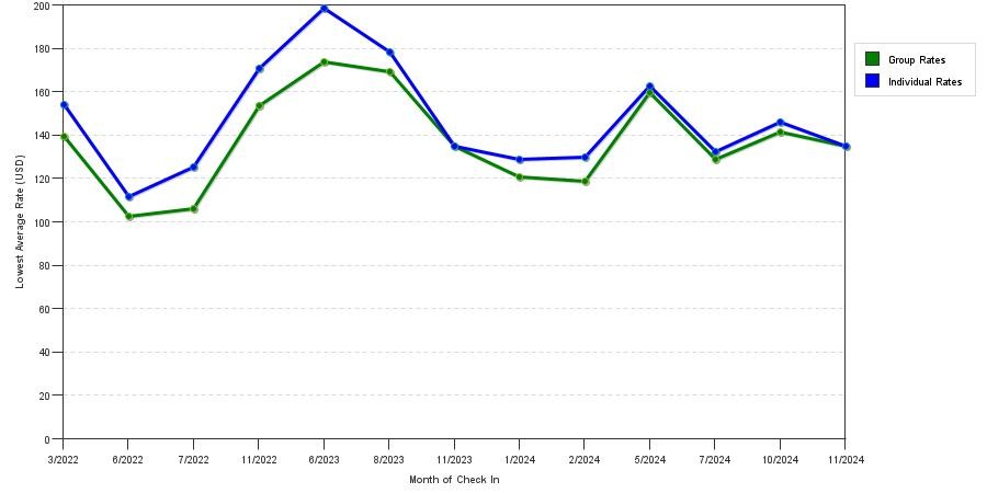
Below is a chart of the current pricing seasonality of hotels and motels in Alsip, IL:
Alsip by Star Rating
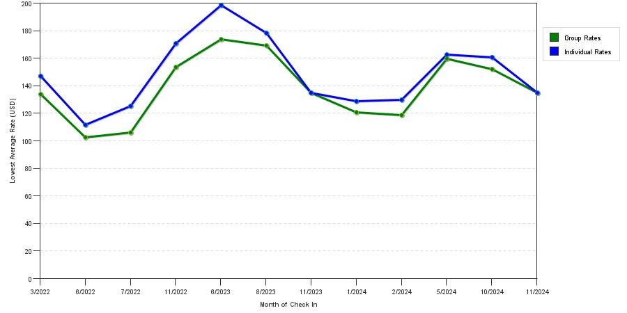
Below are 3 charts demonstrating mean price trends by star rating class in Alsip, IL. You can use these illustrations to determine the least expensive time to book a room in Alsip throughout the year.
Luxury Hotel Options in Alsip, IL
4 Star Average Prices: $128.52
When you're in the mood for five-star accommodation, book a room at the Buckingham Hotel in Chicago. Select from rooms such as as a Grand King Room, a Double Double, or the luxurious, 750-square-foot Corner suites. The best part is that all of these rooms provide stunning, panoramic views of the Chicago skyline. Other in-room amenities include LED televisions with cable programming, deep soaking bathtubs, designer toiletries, a work desk, and phone with local calling.
Staying at the Buckingham gives you plenty of entertainment and relaxation options. Rejuvenate with a relaxing massage or a facial from the on-site spa, play some racquetball at the health club, or splash around in the indoor heated pool. Luggage storage, a business center, and Wi-Fi throughout common areas make it easy for business travelers to get the job done quickly and on time.
Budget Hotel Options in Alsip, IL
3 Star Average Prices: $148.72
When you're searching for budget accommodation in Alsip, you won't have to look too far. With a stay at the Baymont Inn & Suites, you're only a few minutes away from top attractions like Gaelic Park, the Chicago Ridge Shopping Mall, and the Children's Museum of Oak Lawn. Each room comes with top-notch amenities, such as a refrigerator, daily complimentary weekday newspapers, a phone with free local calls, free Wi-Fi, and a flat-screen television with cable programming.
Grab some breakfast at the free continental breakfast to fuel up for your day or your workout in their 24-hour fitness center. Business travelers will also love express check-in and check-out, as well as a 24-hour business center complete with a computer, fax machine, and printer. Have a large group? Inquire about their 800-square-foot meeting room for all your needs.
At the Best Western Inn, you'll get some top-notch amenities for a bargain. Amenities include a business center, free Wi-Fi throughout common areas, a 24-hour front desk so you never feel rushed, and a fitness center to keep your workout routine on track. After checking into your room, you'll be greeted with all the essentials, including a work desk to stay on the job, complimentary newspapers to stay up-to-date on local and national news, free wireless internet to stay connected to friends and family, and cable television for your entertainment needs.
2 Star Average Prices: $147.67
Best Discounts in Alsip, IL
Don't pay full price on your accommodation in Alsip. Instead, take advantage of the discounts available to a number of individuals.
At the Holiday Inn Express, AAA members and seniors with a valid ID can get substantial discounts on their rooms. Located a mile from downtown Alsip, this hotel has plenty to offer, including 123 air-conditioned rooms, each with a flat-screen television, complimentary wired and wireless internet access, and more. Choose from two double beds, a king bed, or a queen bed for a relaxing night's sleep. When you awaken from your swell slumber, head to the lobby to take advantage of a tasty complimentary buffet breakfast.
Value Hotel Options in Alsip, IL
When you don't want to compromise on price or amenities, check out a few of Alsip's mid-range value options.
Located just down the road in Oak Lawn, the Hilton Chicago/Oak Lawn is offers spacious, simple rooms with your choice of a king bed, two queen beds, or two double beds. Get a great rest in one of their 184 hotel rooms, which feature free wireless internet, complimentary toiletries, hair dryers, and flat-screen televisions with cable television.
If you're hungry or thirsty, grab your favorite cocktail or beer at the downstairs bar, or grab a bite to eat at the on-site restaurant. When you want to lounge around the grounds, take a dip in the indoor pool, plan your day with the convenient concierge services, or work up a sweat at the fitness center.
Top Attractions and Destinations in Alsip, IL
Alsip's city limits are rather small, limiting what there is to do in the town, but nearby areas boast more than enough activities, shopping, and dining to entertain you for the duration of the trip.
That said, you can't venture to this area without getting some of Chicago's culinary delights. Deep dish pizza is the most famous treat in Chicago, but with dozens of restaurants serving it up, it's hard to know just where to go. If you want the original, head to Giordano's. With several locations throughout Chicago and the suburbs, delicious pizza is never too far away. Get it with your favorite ingredients such as pepperoni, sausage, and green peppers, or go with extra cheese.
Pequod's Pizza and Lou Malnati's Pizza are two other options that cater to the local crowd, but the verdict's still out on which one's the best.
If you decide to go during the summer, take advantage of the great weather by heading to the beach on Lake Michigan. North Avenue Beach is the most popular of these beaches, featuring retail stores and dining, as well as sweeping, panoramic views of the Chicago skyline.
Another option is Ohio Street Beach, which is an urban oasis in the heart of downtown Chicago. There's no admission, and the beach offers a concession stand and chair rentals to make the trip even more enjoyable. The swimming area is parallel to the shoreline and allows you take a refreshing swim to beat the summer heat.
When you're done taking a dip, head to Grant Park for Lollapalooza, one of the country's premier music festivals. Past performers include Radiohead, Eminem, Kanye West, Smashing Pumpkins, Beastie Boys, Kings of Leon, and more. Each summer, a new lineup of bands converge on the park to showcase their epic sound. You can get tickets for a single day or a pass for the whole festival. When you're done, take some time to explore the park.
As with any major city, you can also choose to simply explore the city on foot. Walk the Magnificent Mile for some upscale shopping, go to a Blackhawks, Fire, Bears, or Cubs game, or just stroll through some of the prettier areas, such as Lincoln Park or Wicker Park. No matter what you choose to do, you're in for a truly authentic Chicago experience.
Whether you're searching for a luxury hotel just outside of Chicago, mid-range options in the suburbs, or budget accommodation, Alsip has the hotels you need to have the trip of a lifetime.
FAQs about hotels in Alsip
How much does a cheap hotel in Alsip cost per night?
In the last year, a 2 star hotel in Alsip can be as cheap as $147.67 per night. (based on HotelPlanner prices)
How much does a 3 star hotel in Alsip cost per night?
In the last year, the average 3 star hotel in Alsip has been $148.72 per night. (based on HotelPlanner prices)
How much does a luxury hotel in Alsip cost?
In the last year, the average 4 star hotel in Alsip has been $128.52 per night. (based on HotelPlanner prices)