When is the best time to visit Langhorne, PA?
If you want the driest, most comfortable weather, most visitors would recommend coming to Langhorne at the end of April through to the beginning of July. Langhorne is very popular as a summer destination, with the majority of tourists visiting in July. Many people also come for Langhorne's snowy winters, with the months of December, January, and February attracting a number of tourists. For the best balance between good weather and good deals, consider coming during May or September.
The least busy month is November, with the majority of hotels dropping their rates. Although the weather can get chilly during the fall, it's generally fairly gentle and there is some nice foliage to enjoy during October. If you're cold-hardy and prepare well, this time of year yields some pleasant hiking and low-cost hotel accommodations.
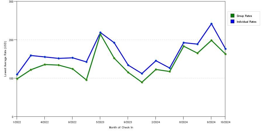
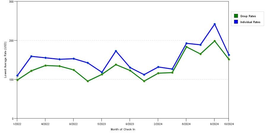
Below is a chart of the current pricing seasonality of hotels and motels in Langhorne, PA:
Averate Rates by Star Rating
Below are 3 charts displaying average nightly cost trends by star rating class in Langhorne, PA. Analyze these charts to determine the cheapest dates to stay in Langhorne during the year.
What are some luxury hotel options in Langhorne, PA?
4 Star Average Prices: $183.20
Luxury accommodations in the Langhorne area are both easy to find and surprisingly affordable, with several high-end hotel complexes located just a short drive away. You can enjoy all the perks of staying at an upscale establishment while being within a convenient driving distance of many local attractions.
One option is the Springhill Suites by Marriott located in nearby Ewing. As well as being conveniently situated near Sesame Place, the hotel is less than 3 miles from Trenton-Mercer airport. Complimentary shuttles are available to carry guests to and from the airport, as well as a free pickup service for the nearest rail station. The hotel allows pets with prior arrangement, but there is a modest pet deposit and a small surcharge. High-speed Wi-Fi is complimentary throughout the hotel.
Rooms are spacious and well-appointed, with pillowtop mattresses on the beds and large bathrooms. The hotel provides a complimentary breakfast; guests can dine at the restaurant and may also pick up food from the on-site grocery and convenience store. The hotel has an indoor pool and provides discounts at a nearby fitness center for guests. Accessibility features are good, with plenty of adapted suites.
Even more luxurious, and ideal for extended stays, is the Langhorne Newtown Homewood Suites by Hilton. Generously sized rooms and spacious suites make longer stays comfortable and productive, with plenty of options for recreation on-site. High-speed wired and wireless internet is provided free of charge. Suites feature full kitchens with fridge-freezers, stovetops, and cooking utensils. All rooms and suites come with 32-inch TVs so that guests can enjoy premium channels.
There's a 24-hour fitness center and an indoor pool for guests to enjoy. The hotel holds a complimentary reception on selected days, while a free hot and cold buffet breakfast is available daily. The hotel has outdoor barbecue grills for guest use -- perfect for a summer cookout. As well as being convenient for local attractions, the Homewood Suites is situated in the business district of Newtown. It has many business-friendly features including a 24-hour business center and generous conference space.
What are some budget-friendly hotels in Langhorne, PA?
3 Star Average Prices: $111.55
The area around Langhorne has some great low-cost accommodations. You can find everything from cozy private rentals to attractively priced hotel rooms and long-stay suites. You can save even more money if you book your stay for midweek rather than during the weekend.
If you're looking for comfortable standard rooms close to the heart of Langhorne, the Oxford Valley Red Roof Inn is a great option. Many of their rooms and suites are fully ADA-compliant, meaning that they're perfect for travelers with disabilities. Bars, roll-in showers, accessible baths, and other helpful adaptations make it easy for mobility-impaired visitors to enjoy a low-cost break. There are also assistive listening devices available. Rooms come with free Wi-Fi, microwaves, coffee makers, and mini fridges or full-size refrigerators. Some rooms also offer a mini bar and a flat-screen TV so you can enjoy your favorite cable programming.
Another great budget option -- especially for those who will be staying longer than a few days -- is the Extended Stay America Philadelphia Bensalem. It's just a quick drive from Langhorne and is also conveniently located for Sesame Place and Parx Casino. The Extended Stay offers comfortable, spacious suites with amenities you'll love. Suites have kitchenettes and full kitchens with stovetops, microwaves, and fridge-freezers. Standard rooms also have microwaves and coffee makers.
The hotel has free Wi-Fi throughout and also offers a free breakfast. Rooms are equipped with flat-screen TVs and cable programming is available. Accessible bathrooms are available in some rooms and suites. The hotel has plenty of recreation facilities including a fully-equipped fitness center. Self-parking is free and wheelchair-accessible.