Visitors can find out more about Whittier's history at several attractions in the city. The Pio Pico State Historic Park is an outdoor space with old buildings worth exploring. The Whittier Museum is a lovely community spot, perfect for exploring how Whittier came to be. When you stay at one of Whittier's hotels, you'll find more to discover about this California city.
When to Visit Whittier, California
Pay attention to the Los Angeles tourism season when visiting Whittier, but don't fret if your trip doesn't perfectly line up with the city's low period of visitation. The metropolitan area is sprawling, and Whittier is far enough away from Los Angeles that you may still find great hotel deals in Whittier when none exist in Los Angeles, especially if you book in advance.
Whittier's temperature is consistent year-round, with the winters dipping only into the high 60s and the summers reaching into the low to mid-80s. Winter is this region's rainy season, and summer is dry. The summer is also when the most tourists arrive in the Los Angeles region.
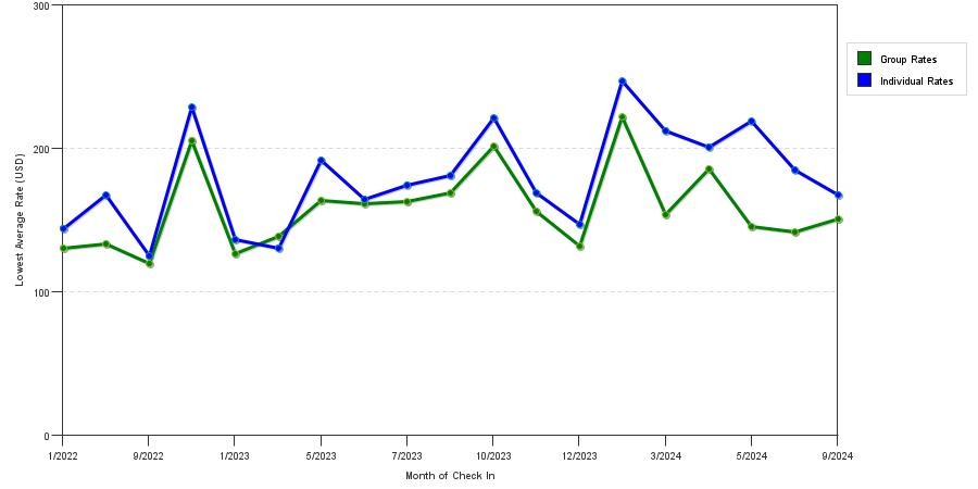
Below is a chart of the current pricing seasonality of hotels and motels in Whittier, CA:
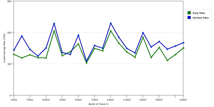
Averate Rates by Star Rating
Below we've posted 3 graphs displaying average price patterns by star rating class in Whittier, CA. Analyze these charts to determine the most cost effective time to book in Whittier for any future trips.
Luxury Hotel Options in Whittier, California
4 Star Average Prices: $141.91
Stay in style in Whittier when you choose the 3.5-star Radison Hotel Whittier. Large, comfortable rooms feature inviting, neutral tones and classic styling, and common spaces are the perfect blend of artistry and warmth. Each room features a Select Comfort bed with a down comforter. Complimentary Wi-Fi, cable, and LCD televisions provide entertainment. Guest rooms equipped with accessible bathrooms, roll-in showers, and in-room accessibility are available. Don't feel like going out to eat? Room service is available during limited hours.
The hotel's outdoor pool features comfortable sun loungers and a spa tub. You'll find a stylish bar at the Radisson, and if you're looking for a party, be sure to check out the property's nightclub. When you want to explore Whittier, board the hotel's complimentary area shuttle, which will take you within a 5-mile radius of the property. Ask the concierge for advice about the best spots to see, dine, or shop in Whittier. Before you go, either grab your favorite latte at the hotel's cafe or stop in the lobby for some complimentary hot coffee or tea.
A few miles from Whittier is Norwalk, California, where you'll find the 3.5-star DoubleTree by Hilton Los Angeles – Norwalk. Enjoy California's sunshine by spending time at the outdoor pool and spa tub. Take a swim in the pool or soak up some rays while lying on comfortable sun loungers. Trees partially shade the area, offering a lovely outdoor ambience. Ask the concierge for anything you may need during your stay and get recommendations for what to do while you're near Whittier. This hotel offers handicap accessibility and rooms equipped with facilities for those with special accessibility needs.
Room service, valet service, and laundry services are all available to make your stay easier and more comfortable. Within each room and suite, you'll find a Sweet Dreams Bed, DoubleTree's bed package designed to make each night heavenly. In the bathroom, combed terry towels offer soft comfort. A desk with an ergonomic chair helps you concentrate on any work you need to get done. Audible alarms and visual strobe alarms are available, too.
Affordable Hotel Options in Whittier, California
3 Star Average Prices: $137.48
Choose the Motel 6 Los Angeles – Whittier for an affordable California stay. Each room on this property has air-conditioning, cable programming, and free local calls. Kitchens with microwaves, stovetops, coffeemakers, and refrigerators help you save money when you stay at the Motel 6. Unlimited Wi-Fi is available for $4.95. Rooms with accessible bathrooms, roll-in showers, and in-room accessibility are available, and the property also offers an outdoor pool, laundry facilities, and a 24-hour front desk.
At the Days Inn Whittier Los Angeles, you'll discover affordable room rates and rooms that offer LED televisions, cable programming, free Wi-Fi, refrigerators, and microwaves. The outdoor pool features a spa tub, and the lobby has free newspapers and coffee. Each morning, you'll enjoy a Days Inn free breakfast. Laundry facilities, fitness facilities, and conference space are also available on this property.